In late winter/early spring of 2013-14, I shared information with readers on the safety corridor re-paving project. Which included a new feature not seen in our area before, of the highway right shoulder getting a red pigment colorization.

photo credit – Chris Butner/completestreetsadvocate.org
Let’s review a few of the basics on this project – The corridor was completely repaved, which required two dry seasons to finish. A widened right shoulder from 8 ft to 10 ft, which serves as a Class III bike facility. The automobile lanes width was narrowed to allow for the wider shoulder. The white fog line next to the right shoulder was also widened, with the rumble strip just inside the fog line. Some other enhancements were made during this project, although this article will just focus on documenting the red shoulder. I have readers outside the Redwood curtain whom are very eager to see what the red shoulder actually looks like.
In this KIEM TV report you can view a short news report on the red shoulder (video included).
What is a Class III bike facility ? Class III bikeway (bike route) are shared facilities which serve to either to:
a) provide continuity to other bike facilities (usually class II bikeways, such as a bike lane)
b) designate preferred routes through a high demand corridor
If you would like to read the full definition, please refer to chapter 1000, page 3 in the highway design manual. Chapter 1000 linked here.
Also note that this red shoulder is a more short-term fix. In an effort for Caltrans to work with the bicycle community. In Humboldt County as a whole this corridor is marked as a high priority for the Humboldt Bay trail project. Much progression has been made on this project. If you’re not familiar with some of the latest news on this project, you can refer to my Humboldt Bay Trail progression page. This includes newly released videos, recent project updates documents, and much more. If you would like to see what the Bay Trail corridor currently looks like you may view my images in this article.
In the Long term with automobile travel. Caltrans is working on an improvement project. Though the Bay Trail must be secured in order for the improvement project to move forward, as directed by the state coastal commision.
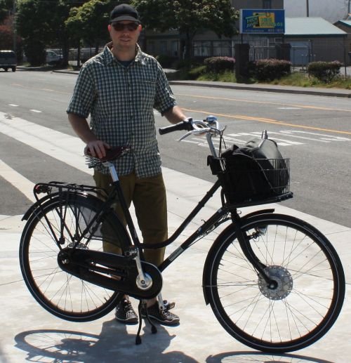
I’m not a big fan of riding a bicycle along the highway. In capturing my pictures for this article, I had ridden my Brompton on a weekend morning when traffic volume was low. The wider shoulder did make it feel like automobiles were a bit further away from me. If it were not for the rumble strips I would not even attempt the highway by bike. At least the rumble strip can warn me of possible trouble, but with gravel to the very right of the shoulder. A fast evacuation probably would end very ugly once my bicycle tires hit the gravel. Colorization, and even an extra two feet of width – tends to not affect my uncomfortable feelings of high-speed traffic racing next to my precious life with no barrier of protection. This is the second time I’ve ridden my bike in the corridor to capture a story for my readers ! Of course I have survived once again to share the images below, so I hope you enjoy the images and informative links.
—————————————-
This first image is the northern end of the southbound side of the highway. This area is just south of Somoa Blvd.

photo credit – Chris Butner/completestreetsadvocate.org
The next image below is passing over the first slough bridge. The red shoulder is missing from this segment, unknown to me why that is.

photo credit – Chris Butner/completestreetsadvocate.org
The next two images show a common site with automobile traffic. Notice the posted speed limit, and the actual speed of passing motorist. This is one contention on why the Humboldt Bay Trail is much-needed.

photo credit – Chris Butner/completestreetsadvocate.org

photo credit – Chris Butner/completestreetsadvocate.org
Below we travel further south entering the Eucalyptus trees area. This segment is challenging for bicycle riders due to a lot of debris falling from the trees above. Not so much debris falling on you, but too much debris along the roadway –

photo credit – Chris Butner/completestreetsadvocate.org
The airport area below, getting closer the Eureka –

photo credit – Chris Butner/completestreetsadvocate.org
The red shoulder on the southbound side ends as you approach the last slough bridge, before you enter Eureka –

photo credit – Chris Butner/completestreetsadvocate.org
The remaining images will be traveling along the northbound side of the corridor.
The image below shows the beginning of the northbound red shoulder. This is at the slough crossing just north of town –

photo credit – Chris Butner/completestreetsadvocate.org
In the below image we show an example of the off ramp. The red pigmentation ceases, then the red continues after the on ramp.
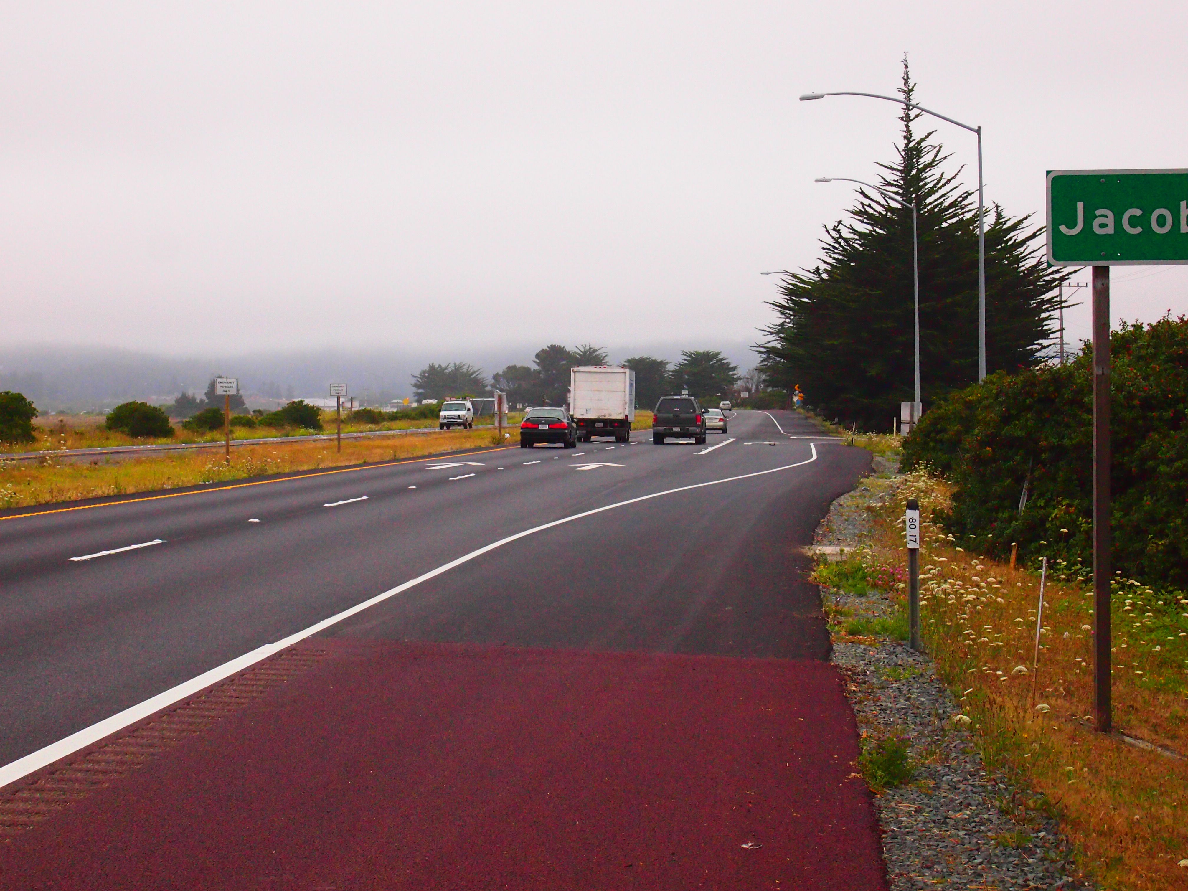
photo credit – Chris Butner/completestreetsadvocate.org
Here on the Humboldt coast the corridor travels through a Tsunami zone –

photo credit – Chris Butner/completestreetsadvocate.org
This area of the state the 101 is also known as the Redwood Highway. Not referring to the red shoulder, but our wonderful Redwood trees !

photo credit – Chris Butner/completestreetsadvocate.org
One of the northbound radar speed signs –

photo credit – Chris Butner/completestreetsadvocate.org
Indianola cutoff area –

photo credit – Chris Butner/completestreetsadvocate.org
Getting closer to Arcata –

photo credit – Chris Butner/completestreetsadvocate.org
This is the northbound end of the red shoulder, just south of Somoa Blvd –
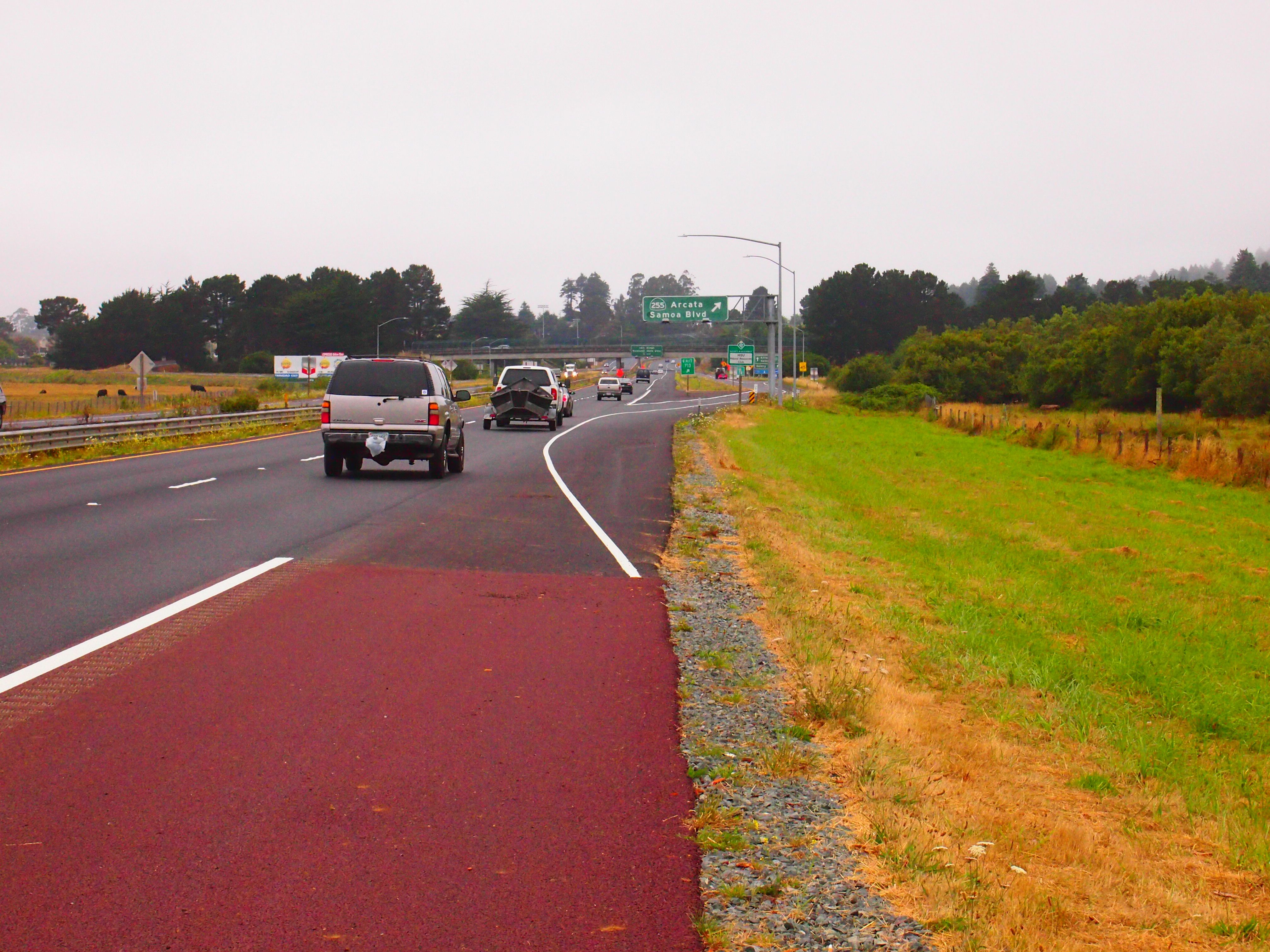
photo credit – Chris Butner/completestreetsadvocate.org
————————–
Thank you for spending time with me on my site ! My main goal with this site is to offer community outreach on transportation topics. I try to share stories of what mainstream media may not cover. My articles can often be unique, compared to what others cover in regards to story content. I thank all for the kind words you have shared with me. The best way you can thank me, is by simply sharing my articles with others. As this helps my goal to spread the information about transportation in the Humboldt Bay region.
May we each transport safely to every destination !!